
Previous issue | Next issue | Archive
Volume 6 (6); 25 November, 2016
 Research Paper
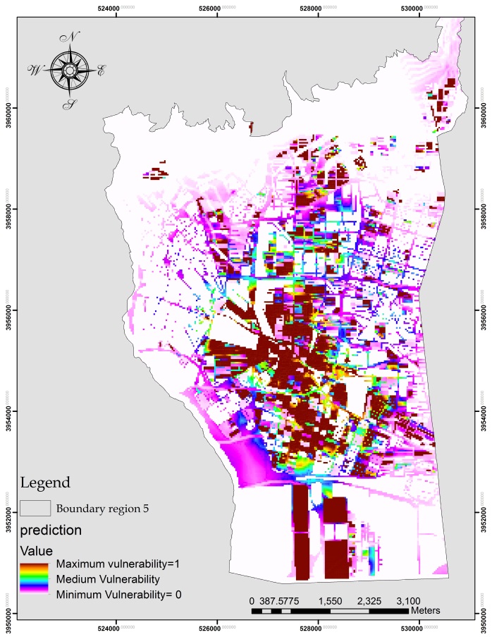
Modeling of Urban Vulnerability Probability (Supposition) Using Logistic Regression Model; Case study: Tehran city.
Maleki S, Meshkini A, Ebrahimi M, Kloraghan A, Moin Mehr A, Omidipoor M.
J. Civil Eng. Urban., 6(6): 94-100, 2016; pii:S225204301600012-6
Abstract
Surveying about city seismic vulnerability is one of the urban management requirements. Using an appropriate model with different spatial and non-spatial data and conducting relevant analysis in Geographic Information System and Multi Criteria Decision model can be as useful tools in urban management. The objective of this study is assessing the vulnerability potential of the region 5 of Tehran using logistic regression model. In this study, 14 indicators are used to estimate the vulnerability: Substructure's area of all floors in the block, distance from crisis management centers, Block's area, distance from Gas reducer center and Transmission substation, block's population, Access to communication road, old texture regions, distance from parks and green space, distance from gas and gasoline stations, distance from fault, distance from fire station centers, distance from hospitals and health centers, Average of the block's floor, Slope of the region. Output from 0.83 to 1 class of the SAW model is used as dependent variable to generate the vulnerability distribution map for Logistic regression analysis in IDRISI software. As a result, blocks population (with value of 37.05) and average of the block's floor (with coefficient of 11.6) have the greatest impact on vulnerability. Roc criterion is used for the evaluation of model. The value for this criterion is calculated as 0.996 which shows strong relationship with the values obtained from the logistic regression model.
Key words: Vulnerability, Logistic Regression, Geographic Information System, spatial and non-spatial data

Research Paper
Numerical Analysis of Concrete Solider Pile with Steel Sheet Pile Lagging Supporting System in Sandy Soil.
Abd El-Naiem MA, Rushedy Towfeek A, Abd El-Samea WH.
J. Civil Eng. Urban., 6(6): 93-101, 2016; pii:S225204301600013-6
Abstract
Deep excavations have been used worldwide for underground construction, reliable prediction of ground deformations are essential in the design process for assessing the effects of excavation on adjacent facilities; and identifying sections where special remedial construction measures are required. Available techniques for estimating wall deflections and soil settlements involve either interpolation from existing empirical databases or numerical analyses using finite element method, which is considered an effective way to investigate the performance of deep excavations. This paper presents numerical analysis of concrete solider pile with steel sheet pile lagging supporting system in sandy soil using three dimensional finite element modeling. (3D FEM) PLAXIS 3D foundation software program was used in the analysis. A parametric study was performed to study the effect of spacing between piles, piles stiffness, type of sandy soil and the influence of using cap beam at piles head. Lateral displacement and bending moment of both solider pile and sheet pile lagging ware investigated and comparison between solider pile wall support system and sheet pile wall support system was achieved.
Keywords: Solider Pile, Sheet Pile Lagging, Deep Excavation, Cap Beam.
[Full text-PDF] [DOAJ]
Previous issue | Next issue | Archive