|
Research Title/ Field
|
Article (Abstract)
|
Download
|
|
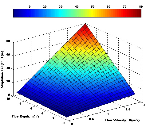
The Portion of the Influent Parameters on Adaptation Length in Sediment Transport in Numerical Models
|
Original Article, B36
Fuladipanah M, Majediasl M.
Journal. Civil Eng. Urban. 2(6): 202-206. 2012.
ABSTRACT:River flow and sediment transportation are two phenomena, which are taken place in alluvial streams. The complexity of the simulation of this phenomena have been caused numerous numerical models which are consists of different parameters. The un-equilibrium nature of sediment transport has been caused using un-equilibrium predictor. Adaptation length is one of the most important parameters in this type of equations, which is function of four parameters: flow depth, flow velocity, adaptation coefficient, and sediment fall velocity. Determining of sensitivity level of four mentioned parameters is discussed in this paper. The FAST technique, which is variance based sensitivity method, was applied in this research. According to the results, the first order FAST based sensitivity indices, explain 81.42% of the total variance, i.e., the result of this technique is acceptable. Results showed that sediment fall velocity has the most parameter, which must be measured with high accuracy. In addition, it was found that sediment particle properties are more effective than flow properties.
Keywords:River, Sediment, Adaptation length, numerical models, sensitivity analysis.
|

|
|
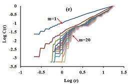
The Presence of Chaotic Behavior in Monthly Soil Temperature Time Series by Correlation Dimension Method
|
Original Article, B37
Aalami M.T.
Journal. Civil Eng. Urban. 2(6): 207-213. 2012.
ABSTRACT:Soil temperature can fluctuate dynamically, suggesting a possible chaotic behavior in such time series, as this can have a significant bearing on hydrological models, solar energy and other agricultural applications. Hence, this paper reports an investigation into the detection of a possible existence of chaotic behavior in the monthly soil temperature time series at five depths (5, 10, 20, 50 and 100 cm) below the ground level in a recorded data (an observation station in Adana, Turkey). For this purpose, the correlation dimension method, as a customary indicator of chaotic behavior, was derived from the data record over a period of 8 years (January 2000 - December 2007). The low correlation dimensions at five depths suggest the presence of low-dimensional chaotic behavior in the soil temperature dynamics.
Keywords:Chaos theory, Correlation dimension, Time series, Soil temperature
|
|
|
Assessment of Ground-Water Quality in the South-East of England
|
Original Article, B38
Louis IA and Egbuna CK.
Journal. Civil Eng. Urban. 2(6): 214-219. 2012.
ABSTRACT:This study assesses the groundwater quality in the South-East England. Borehole water samples were collected at different locations across 7 different sites in the South-East of England. 14 physicochemical and 2 microbiological parameters (E. coli and enterococci spp) of the groundwater were analysed. Results showed that although all the physicochemical parameters met the WHO and EC Water Directive (98/83/EEC) guideline values, the presence of E.coli and enterococci were detected in the entire sites except for one. The presence of these micro-organisms could be attributed to the proximity to the sewage treatment discharge which could have mixed with the ground water via seepage and intrusion of animal faeces into the groundwater.
Keywords:E.coli, Groundwater Quality, WHO, Assessment, Physicochemical Parameter. |
|
|
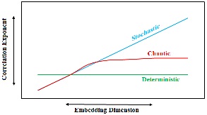
Evidence of Low-Dimensional Determinism in Monthly Water Level Time Series in Lake Van, Turkey
|
Original Article, B39
Daneshfaraz R, Asadi H, Saghebian SM.
Journal. Civil Eng. Urban. 2(6): 220-225. 2012.
ABSTRACT:Adequate knowledge of lake water level variations is important for proper planning and management of water resources and design of environment. In this study chaotic behavior of monthly water level variations in the lake Van during January 1944 - April 2002 is investigated. The lake Van is the largest lake in Turkey. The methods and indicators of chaos theory (power spectrum, average mutual information, false nearest neighbours, correlation dimension and largest Lyapunov exponents) were applied. The value of power spectrum (4.1) indicate that chaotic (fractal) behavior to the lake water level time series. The optimal delay time (5 month) and embedding dimension (5) are obtained from average mutual information and false nearest neighbours techniques, respectively. Optimal values are then used for the estimation of the correlation dimension and the largest Lyapunov exponent for inspecting possible signatures of chaotic dynamics. The low correlation dimension (3.2) suggest the presence of low-dimensional chaos; also imply that the water level dynamics are dominantly governed by four variables. The positive largest Lyapunov exponent value (0.0085) indicated a signature of chaos. These results give a positive indication towards considering lake water level as a chaotic system.
Keywords:Chaos theory, Correlation dimension, Lyapunov exponent, Power spectrum, Time series, Van Lake. |
|
|
Optimum Location of Neighbourhood Parks in Bonab City Using Analytic Network Process (ANP)
|
Original Article, B40
Sarvar R, Rashidi Ebrahim Hesari A, Mousavi M.N, Orooji H.
Journal. Civil Eng. Urban. 2(6): 226-234. 2012.
ABSTRACT:The study aims at qualifying the new sites, which are consistent with the relevant construction standards, for building neighbourhood parks. Accordingly, the Analytic Network Process (ANP) was employed. In this technique, the relationships among various elements and clusters are examined with the aim of finding the optimum site. Hence, the eleven elements namely land area, population density (people per km2), household density, household dimension, slope, the distance between the site and the residential, cultural and educational centres, access to major thoroughfares and roads, the distance away from rivers and watercourses, the distance away from the present parks and green spaces. Decision-Making Trial and Evaluation Laboratory (DEMATEL) method was used to define the relationships among the mentioned elements and then the pair wise comparisons were conducted using questionnaires. Finally, Super Decisions was used to measure the final coefficients of all elements. The spatial information of all elements including their impacts on park building were classified using Arc GIS and then the weights gained from ANP were applied to them and eventually the final map was depicted. The results suggests that some parts of districts 1, 4, 7, 9, and 13 in Bonab City are the best sites for building neighbourhood parks which must be considered in the urban planning projects.
Keywords:Neighbourhood parks, Bonab, Analytic Network Process (ANP), green spaces, optimum location.
|
|
|
Concept, Giving Form to an Idea
|
Technical Note, B41
Dorraj P , Farzaneh M , Salaji N
Journal. Civil Eng. Urban. 2(6): 235-238. 2012.
ABSTRACT:Creation of architecture is a process in which an image changes into a project. The trend of the process and how it changes into an architectural space is always one of the concerns of the designers and the architects. To account for the mind manifestation and with regard to the fact that this field is a combination of art and technique, and today the technology and the digital media have joined it, and also combining of these subjects and the challenges that always exist between concept and idea and their definition and interaction between these two phenomena have led the scholars to different directions and everyone has given some strategies according to the subject and functions.Since, today, the subject of architecture especially in its theoretical process has changed into the Text and even in some stages has changed into the Context, therefore understanding these terms and studying the coexisting aspects of these subjects beside each other and paying attention to one special subject which is used in this field today are the main points of this paper.The Conceptual Art and on the basis of it , the Conceptual Architecture, is one of its indices whose formation and functions and effects on architecture in the today world have been analyzed and its comparative process has been assessed especially in the architecture of Iran.
Keywords:Image, idea, concept, conceptual art, conceptual architecture.
|
|
|
The Effect of a Sluice Gate Edge on Water Surface Profile
|
Original Article, B42
Mohammed A.Y, and Khaleel M.S.
Journal. Civil Eng. Urban. 2(6): 239-243. 2012.
ABSTRACT:In this paper the effect of the lower gate edge on the water surface profile (W.S.P) have been studied in a rectangular flume with four gate openings (2, 3, 4 and 4.5) cm, five upstream of water heads (18.9,21,24,26 and 28.9) cm and five gate cases (vertical and inclined vertically by angle (45)o with and opposite to flow direction )with horizontal and sharp lower edge ( inclined by angle (45)o ) Were adopted in the experiments. The results show that the convergence length for inclined gate with flow direction and horizontal edge increases by (28.7)"%" with respect to vertical, while decreases by (21.4)"%" when gate inclined opposite to flow direction and horizontal edge. The convergence angle decreases by (38.7)"%" when gate inclined with flow direction and horizontal edge, while increase by (22.4)"%" when gate inclined opposite flow direction and horizontal edge. The horizontal lip for the inclined gate with flow direction reduced the (W.S.P) convergence angle and then reduced the scour downstream sluice gate.
Keywords:sluice gate, water surface profile, tail water, finite elements
|
|
